
See our list of the top free software for photogrammetry currently on the market. All of it is free.
A method called photogrammetry uses photos to build 3D models of actual objects in the environment to collect accurate data about them.
Surveyors, architects, engineers, and contractors frequently use photogrammetry to produce topographic maps, networks, or point clouds. With the help of overlapping photos of a structure, object, or landscape, 2D and 3D data are extracted from an image and transformed into a digital 3D model. Large objects, including landscapes that would be impossible to scan before, can now be captured.
Software for photogrammetry can take many different forms. Of course, commercially available solutions are perfect for use in engineering and industrial settings. But if you want to give it a shot, there are also several programs that you can download for free. To capture the models, all you need is a camera or smartphone. If you have access to a 3D printer, you can even print the models afterward.
We have created a list of the top software for photogrammetry available today, divided into categories, and listed alphabetically. The best free software for photogrammetry tools are examined first. We then introduce you to the expert software used to make stunning 3D models.
Also, read our Photogrammetry Overview at the end of this article if you want to learn more about some basic terminology and the differences between software for photogrammetry.
Types of Photogrammetry

Typically, software for photogrammetry operates as follows: It calculates the distances between each image’s shared points in 3D space and automatically registers them. The end result is a point cloud that can be converted into a 3D mesh. A few more sophisticated programs also offer tools for cleaning the point cloud to improve the overall quality.
There must be enough image data for the software tools used in photogrammetry to function correctly. The motion technique structure uses natural elements like tree bark and other dense textures. These are helpful for scanning objects with difficult-to-process features or surfaces that are reflective and/or transparent. If appropriately used, coded markers can produce results with greater accuracy than the motion technique’s structure.
Most software for photogrammetry is exclusively made to produce a point cloud or a high-quality 3D mesh. To perform measurements, annotate the map, or enrich the data, some programs also offer their own analysis tools within the workspace. Infrastructure firms, forestry organizations, coast-line management organizations, and similar organizations frequently use such solutions.
Applications of Software for Photogrammetry
Building Design and Renovation
Elevation drawings and surveying of the surrounding area can be done using photogrammetry software. There are frequently no plans to use as a guide for planners when renovating existing buildings. In these situations, using photogrammetry software to generate precise outlines and measurements that can be imported into CAD and BIM software to launch the project is a cost-effective method.
DIGITAL PRESERVATION
Archaeology and the preservation of cultural heritage are two other fascinating fields that use photogrammetry software. In the past, the elevations, facades, and contours of buildings and other structures were measured by archaeologists, then depicted on maps and plans. The recent upsurge in photogrammetry software has created new opportunities for preserving the monuments of previous generations and making them accessible to future generations for study and interpretation.
GEOLOGY AND MINING
Numerous other fields, including geology, mining, and quarrying, offer applications for photogrammetry software. The generation of point clouds and elevation maps using this technology is more affordable than conventional surveying techniques. Professional software for photogrammetry solutions give users access to specific analytical tools that let them quickly measure stockpiles and pits.
Top 7 Free Software for Photogrammetry
Meshroom
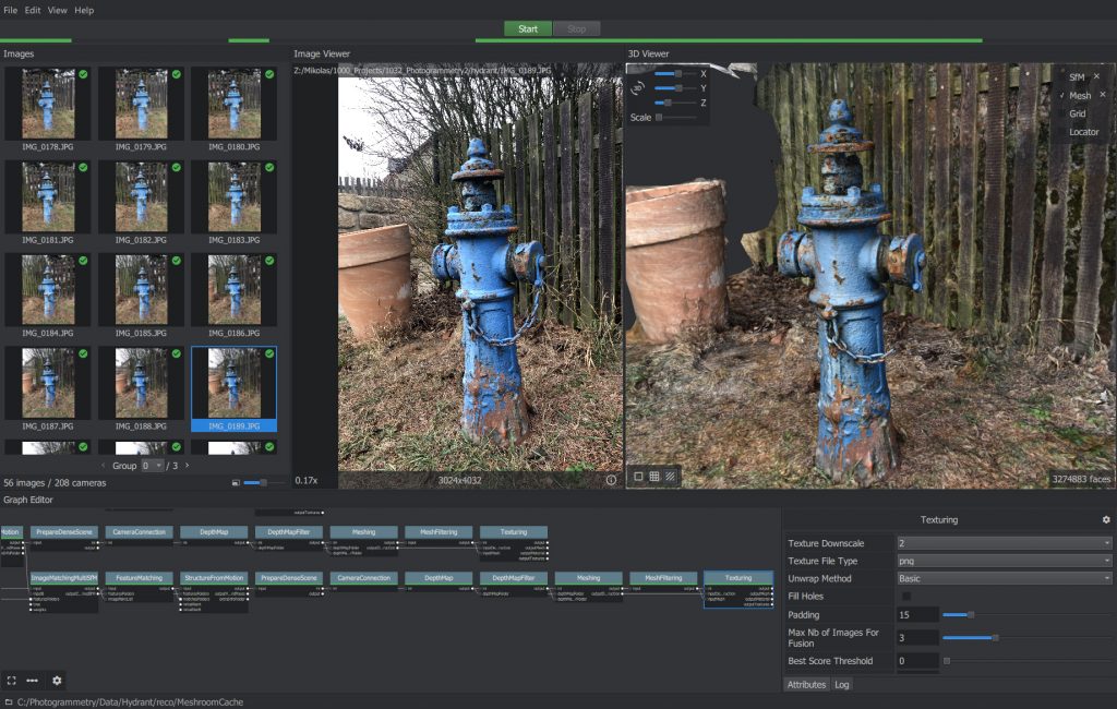
A free and open-source photogrammetry program, Meshroom is built on the AliceVision framework. The computer program generates an object mesh and calculates the separation between surface points. With it, a 3D model can be created using images of an object taken from various angles.
The application is designed around a user-friendly, node-based workflow that connects each step to produce a 3D model. In some other programs, these would need to be turned on individually, but since they make up a single pipeline of nodes in Meshroom, turning them on only requires one click.
You can adjust any of these nodes to produce the desired outcome. For instance, select the texture node to alter the texture map’s resolution to suit the intended use, such as high-resolution rendering or mobile gaming. Your results will improve as you spend more time using this free photogrammetry software. However, this complex pipeline serves no purpose when you only need to press a single button.
If you use Autodesk Maya, you can use the software inside the 3D modeler by downloading the free Meshroom plugin from the website.

Download: AliceVision
Type: Aerial, Close-Range
OS: Windows, Linux
Price: Free
COLMAP

You can download COLMAP, a free software for photogrammetry, from Github. You can run it from the command line or executively, just like any other program with a GUI. Like most of the other photogrammetry programs on this list, COLMAP can automatically reconstruct 3D objects from single-camera or stereo setups.
However, because COLMAP was developed by researchers, it also has a lot of highly sophisticated options. You must use additional programs like MeshLab to polish and improve the 3D mesh. These are not required for users who want to create a 3D mesh quickly and easily, but they will unquestionably enhance the quality. You could, for instance, describe in great detail the kind of camera used to take the pictures. The feature extraction procedure can also be adjusted to produce the best results. The program can export a 3D mesh, but the only viewport you can use is the dense point cloud one.
Download: GitHub
Type: Aerial, Close-Range
OS: Windows, macOS, Linux
Price: Free
MicMac
The French National Geographic Institute and the French National School of Geographic Sciences have created MicMac, a free, open-source photogrammetry program. MicMac is a versatile tool used successfully in cartography, environmental protection, forestry, cultural heritage preservation, and private industries. It is the result of ongoing research and teaching experience. Although it is also available to casual users, its complex feature set best suits professional or academic users.
MicMac may be used to produce orthographic photos and 3D models. Any object kind and scale can be presented to the photogrammetry software without issue. It can scan small items and extensive areas of ground with equal efficiency. It can also process photographs taken from a close distance and air. Even metrology and site surveying is made possible by some editing tools. The extensive tutorials and tips on the MicMac website will quickly get you up to speed.
Download: MicMac
Type: Aerial, Close-Range
OS: Windows, macOS, Linux
Price: Free
Multi-View Environment
A complete end-to-end pipeline for image-based geometry reconstruction is the Multi-View Environment (MVE). The command-line apps can be used to automate your processes. Still, most capabilities are also accessible through the UMVE user interface.
Surface Reconstruction, Multi-View Stereo, and Structure-from-Motion are included.
The software’s interface isn’t particularly impressive. To use it to its best potential, you should carefully read the manual before beginning; yet, once you have, it produces good results relatively quickly.
Download: MVE
Type: Aerial, Close-Range
OS: Windows, macOS
Price: Free
OpenMVG

Popular among computer vision researchers in the Multiple View Geometry (MVG) community is the OpenMVG library, which is geared at photogrammetry. Structure from motion (SfM) photogrammetry is typically the focus, and several integrated tools are developed around it.
Its models and features are tested to ensure they function correctly under real-world conditions.
Some computer knowledge is needed to get the OpenMVG photogrammetry pipeline functioning. OpenMVG is still a useful tool that integrates into the workflows of other photogrammetry programs thanks to its community-focused accessibility.
Download: GitHub
Type: Aerial, Close-Range
OS: Windows, macOS, Linux
Price: Free
Regard3D
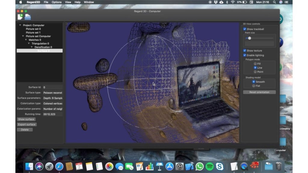
Regard3D is a free and open-source photogrammetry program that creates 3D models of objects from images taken from various perspectives using the structure from motion (SfM) technique.
It is a fascinating piece of software that provides a robust toolkit for altering the point cloud before creating a 3D mesh, either by adding colored vertices or a texture.
However, it could take some time to become used to and feel at ease with all the options and features that Regard3D allows you to change before you get the desired results. However, even if you have never used photogrammetry software before, this is a terrific place to start because Regard3D’s website has all the training and guidance you require to get going immediately.
Download: Regard3D
Type: Aerial, Close-Range
OS: Windows, macOS, Linux
Price: Free
VisualSFM

As the name implies, VisualSFM is a photogrammetry program that creates point clouds using the structure from motion (SfM) technique. The software can match features, detect them, and change packages. Users can use a GUI or the command line to do tasks.
The fundamental method of producing a point cloud requires no more than four button clicks, even though die-hard photogrammetry fans can go crazy with dozens of parameter changes to customize the outcomes. VisualSFM was created by Google software developer Changchang Wu and is used in both Wu’s own research and that of other experts in the field. Please be aware that only this program’s personal, nonprofit, or academic usage is free.
Download: CCWU
Type: Aerial, Close-Range
OS: Windows, macOS, Linux
Price: Free


